

Geography Grade 12 Research Tasks (Topics) and Memos (SBA)

Geography Grade 12 Research Tasks (Topics) and Memos for: term 1, Term 2, Term 3 and Term 4
Assessment is a continuous planned process of identifying, gathering and interpreting information about the performance of learners, using various forms of assessment. It involves four steps: generating and collecting evidence of achievement; evaluating this evidence; recording the findings and using this information to understand and assist with the learners’ development to improve the process of learning and teaching. Assessment should be both informal (assessment for learning) and formal (assessment of learning). In both cases regular feedback should be provided to learners to enhance the learning experience.
School-based assessment (SBA) is a purposive collection of learners’ work that tells the story of learners’ efforts, progress or achievement in given areas. The quality of SBA tasks is integral to learners’ preparation for the final examinations.
This booklet serves as a resource of four exemplar SBA tasks to schools and subject teachers of Geography. SBA marks are formally recorded by the teacher for progression and certification purposes. The SBA component is compulsory for all learners. Learners who cannot comply with the requirements specified according to the policy may not be eligible to enter for the subject in the final examination.
The formal assessment tasks provide the teacher with a systematic way of evaluating how well learners are progressing. This publication includes tests, a project and a case study. Formal assessment tasks form part of a year-long formal programme of assessment. These tasks should not be taken lightly and learners should be encouraged to submit their best possible efforts for final assessment.
The teachers are expected to ensure that assessment tasks are relevant to and suitable for the learners being taught. Teachers should adapt the tasks to suit learners’ level of understanding and should be context-bound; however, they should also take cognisance of the requirements as set out in the Curriculum and Assessment Policy Statement ( CAPS ) document.
What Skills are Assessed for Research Tasks in Grade 12
The following skills are assessed. Some/All of these skills may be tested in any external examination:
- Gathering data
- Interpreting data
- Analysing data
- Comparing different sets of data
- Representing data in written, graphic or mapped format
- Problem-solving
- Drawing conclusions
- Hypothesis statements
Research framework for assessment (Guideline on administration of research task)
Step 1: Formulating a hypothesis/problem statement.
Guideline: geography grade 12 research tasks.
Step 1: Formulating a hypothesis/problem statement. As Geographers we seek to understand and explain the interactions amongst humans, and between humans and the environment in space and time. This is achieved by asking questions or making informed geographical decisions. This entails the development of a hypothesis or a problem statement to be tested.
- You have to choose a specific area of study where a geographical problem exists.
- During this stage, a geographical question showing a problem is asked.
- Identify the problem from a local area.
- Formulate a hypothesis or a problem statement. (Hypothesis research is used to prove that certain variables are dependent on or independent of each other. Problem statement research is only to highlight that a specific problem exists in a specific community.)
- You should then follow the steps of research to ensure that the geographical question is answered.
Geography Research Project Topics for Grade 12 South Africa
- The value of property along north-facing slopes is higher than the value of property along south-facing slopes in Meyersdal, Gauteng (choose local area).
- The cause of rural-urban migration in Ndwedwe, KwaZulu-Natal (choose local area), is the lack of service delivery in the health sector.
- Climate change will impact negatively on grape farming and related industries in the Western Cape.
- The closing down of many primary schools in Lusikisiki (Eastern Cape) (choose a local area) is due to a decline of the population in the age group 7 to 15 years.
- The poor condition of roads (specify the names of the roads) leading to/in Harrismith, Free State (choose local area), is due to the lack of proper planning by the local municipality.
- The impact of building a dam along the Jukskei River in Gauteng (choose local area) upstream of Alexandra will reduce flooding and the subsequent loss of life in Alexandra.
- The e-toll system will impact negatively on the economic position of people using private transport in Gauteng.
- The e-toll system will impact positively on traffic flow to the major urban centres in Gauteng.
- Informal settlements in the Vhembe district of Limpopo have low levels of development due to the lack of provision of basic needs (choose ONE informal settlement in your local area.)
- Overcrowding of informal settlements is due to the lack of proper planning by the local government (choose local area).
Step 2: Background information about an area of study
- You must explain where in South Africa the study area is located. (This can be indicated on the map.)
- Describe the study area in terms of its exact position (degrees, minutes and seconds).
- Provide relevant information about the area, for example population of the area or climate of the area.
Step 3: Mapping
- You must provide a map of the area in question.
- During this stage you must create a buffer zone around the area where the geographical problem exists.
- The map should have a clear legend/key and must be drawn to scale. The scale must be indicated on the map.
- If the map used covers a wider area, buffer zones around the area of study should be created.
- The map used should be the most recent map of the study area
Step 4: Methods of data collection
(a) PRIMARY DATA SOURCES
- The use of questionnaires
- Observations
- Field trips
(b) SECONDARY DATA SOURCES
- Newspaper articles
- Government department statistics
Step 5: Analysis and synthesis of data
• Learners must use collected data now to formulate a discussion around the existing geographical problem. • At this stage learners should represent some of the information graphically where necessary, for example graphs and sketches. • Learners must analyse graphic information during this stage.
Step 6: Recommendations and possible solutions
• Learners should now make recommendations to solve the geographical problem in question. • Learners should present their original and realistic opinions as far as they possibly can.
Step 7: Conclusion – accept or reject the hypothesis
- Learners should now take a decision to either ACCEPT or REJECT the hypothesis.
- Learners must give reasons for either ACCEPTING or REJECTING the hypothesis
Step 8: Bibliography
- Learners must include a comprehensive bibliography.
- Learners must list websites in full.
- Learners must include annexures of questionnaires and interviews conducted
More Geography Grade 12 Resources
- Geography 2020 Past Papers
- Geography 2019 Past Papers
- Grade 12 Geography Exam Papers and Memos for 2019 September and November
- Geography Grade 12 Research Tasks (Topics) and Memos
Looking for something specific?
Leave a comment.
Save my name, email, and website in this browser for the next time I comment.
You May Also Like

Hypothesis on Tropical Cyclone Freddy in Mozambique

One way in which Global Warming Aggravates the Effect of Radiation

How Tropical Cyclone Eloise Impacted the Environment

The Path of the Tropical Cyclone Ana: Satellite Image Map
GEOGRAPHY SCHOOL BASED ASSESSMENT EXEMPLARS - CAPS GRADE 12 LEARNER'S GUIDE
GEOGRAPHY SCHOOL BASED ASSESSMENT EXEMPLARS - CAPS GRADE 12 LEARNER GUIDE
| 1 | Introduction | 3 | ||
| 2 | Objectives/Aims of the project | 3 | ||
| 3 | Assessment tasks as outlined by CAPS | 3 | ||
| 4 | Assessment tasks | 4 | ||
| 4.1 | Term 1 – Data-handling task | 4 | ||
| 4.1.1 | Exemplar: Data-handling task 1 | 4 | ||
| 4.1.2 | Exemplar: Data-handling task 2 | 8 | ||
| 4.2 | Term 2 – Research task | 12 | ||
| 4.2.1 | Learner guidelines for conducting research | 12 | ||
| 4.2.2 | Guidelines for research | 12 | ||
| 4.2.3 | Compiling a bibliography for a research task | 15 | ||
| 4.2.4 | Proposed cover page for a research task | 17 | ||
| 4.2.5 | Exemplar: Research task 1 | 18 | ||
| 4.2.6 | Exemplar: Research task 2 | 20 | ||
| 4.2.7 | Proposed marking rubric for a research task | 22 | ||
| 5 | Conclusion | 25 | ||
1. Introduction The purpose of this document is to provide learners with a set of benchmarked school- based assessment tasks (SBAs). It contains useful information and guidelines in the form of exemplars on the following aspects of the curriculum:
- How to do a research task
- Working with sources and source-based questions
- Data handling
- Marking rubrics as guidelines to completing research tasks
2. Objectives/Aims of the project It is envisaged that this SBA document will provide learners with examples of SBA tasks that are of high quality and a high standard.
- A common standard is set as prescribed by the Curriculum and Assessment Policy Statement (CAPS) document.
- Quality teaching and learning of FET – Grade 12 Geography is promoted throughout all schools in South Africa.
3. Assessment tasks as outlined by CAPS
|
|
|
|
SBA mark which comprises 25% of final mark (100 marks) | 75% of final mark (300 marks) |
|
|
|
|
| |
1 | Data handling | 60 | 20 | 100 (25%) | |
Standardised test | 100 | 10 | |||
2 | Mapwork task | 60 | 20 | ||
June Paper 1 | 200 | 300 | 10 | ||
June Paper 2 | 100 | ||||
3 | Research/Essay writing task | 60 | 20 | ||
Standardised test | 100 | 10 | |||
Trial Paper 1 | 225 | 300 | 10 | ||
Trial Paper 2 | 75 | ||||
4 | External Paper 1 | 225 | 300 | 300 (75%) | |
External Paper 2 | 75 | ||||
4. Assessment tasks 4.1 Term 1 – Data-handling task Two examples of typical data-handling tasks are provided below.
4.1.1 Exemplar: Data-handling task 1
- Curriculum content: Physical Geography (tropical cyclones, subtropical anti-cyclones and drainage basins) • Compliant with CAPS.
- May be tested in the CAPS final external examination.
- One (1) data-handling task must be done.
GRADE 12 SBA (CAPS 2014) DATA-HANDLING TASK PHYSICAL GEOGRAPHY
TIME: 1 hour (60 minutes) MARKS: 60 QUESTION 1 1.1 Refer to FIGURE 1A showing a synoptic weather map of Tropical Cyclone Irina.
1.1.1 Determine the number of tropical cyclones, including Irina, that has occurred during this tropical cyclone season. (1 x 2) (2) 1.1.2 Give a reason to support your answer to QUESTION 1.1.1. (1 x 2) (2) 1.1.3 Describe the surface air circulation within Tropical Cyclone Irina. (1 x 2) (2)
1.2 Refer to FIGURE 1B showing a satellite image of Tropical Cyclone Irina and FIGURE 1C showing the projected path of Tropical Cyclone Irina.
1.2.1 Using the satellite image, determine in which stage of development Tropical Cyclone Irina is. (1 x 2) (2) 1.2.2 Give evidence from the satellite image to support your answer to QUESTION 1.2.1 (1 x 2) (2) 1.2.3 Discuss TWO socio-economic impacts of Tropical Cyclone Irina on areas along the east coast of southern Africa. (2 x 2) (4) 1.2.4 Draw a labelled cross-section of Tropical Cyclone Irina as depicted on the satellite image from X to Y. Clearly indicate the position of the eye and the cumulonimbus clouds on your cross-section. (2 x 2) (4) 1.2.5 State the reason for the use of the words, ‘projected path’ when describing the path of Tropical Cyclone Irina. (1 x 2) (2)
1.3 Refer to FIGURE 1A.
1.3.1 Identify the high-pressure cells labelled P and Q. (2 x 2) (4) 1.3.2 Use evidence from the map to explain whether wind speed will be greater in area P or area Q. (3 x 2) (6)
QUESTION 2 2.1 Refer to FIGURE 2A showing cross-sections of the Tugela River along its course in its drainage basin shown in FIGURE 2B.
2.1.1 Define the term drainage basin. (1 x 2) (2) 2.1.2 Which of FIGURE 2A and FIGURE 2B shows a longitudinal and transverse profile respectively? (2 x 2) (4) 2.1.3 Match each of cross-sections A, B and C (FIGURE 2A) with positions (i), (ii) and (iii) (FIGURE 2B). (3 x 2) (6) 2.1.4 Briefly explain the difference in the width of the river channel at A and C. (2 x 2) (4)
2.2 Refer to FIGURE 2B showing the drainage basin of the Tugela River from its upper to the middle to the lower course.
2.2.1 Determine the stream order of the Tugela River at point X along its course. 1 x 2) (2) 2.2.2 Identify and explain ONE of the stream channel patterns of the Tugela River at (ii) along its course. (3 x 2) (6) 2.2.3 Draw a labelled free-hand cross-section through the river channel along line T–S, showing the position of and the difference in shape between a slip-off slope and an undercut slope. (2 x 2) (4) 2.2.4 Give ONE reason why the Tugela River is more likely to flood in the vicinity of (iii). (1 x 2) (2)
[30] GRAND TOTAL: 60
4.1.2 Exemplar: Data-handling task 2
- Curriculum content: People and their needs (gross domestic product, industrial areas, industrial development zones [IDZ])
- Compliant with CAPS.
- May be tested in the NCS and CAPS final external examination.
GRADE 12 SBA (CAPS 2014) DATA-HANDLING TASK PEOPLE AND THEIR NEEDS
TIME: 1 hour (60 minutes) MARKS: 60 QUESTION 1 1.1 Refer to FIGURES 1A and 1B and answer the questions that follow.
1.1.1 Define the following terms:
- Gross domestic product (1 x 2) (2)
- Balance of trade (1 x 2) (2)
1.2 Identify the largest and the smallest contributor to the South African GDP. (2 x 2) (4) 1.3 Use FIGURE 1B to describe the trend of the South African GDP from 2010 to 2012. (1 x 2) (2) 1.4 How will the trend mentioned in QUESTION 1.3 affect South Africa’s Balance of Trade? (1 x 2) (2) 1.5 Which economic activity (primary, secondary or tertiary) in FIGURE 1A accounts for the existing trend mentioned in QUESTION 1.3? (1 x 2) (2) 1.6 Discuss the relationship between the percentage contributed by agriculture to the South African GDP and food security in the country. (2 x 2) (4) 1.7 FIGURE 1A indicates that the agricultural sector contributes a very small percentage to the GDP. Write a short paragraph (approximately 12 lines) in which you account for the small contribution of the agricultural sector to the South African GDP. (6 x 2) (12)
| ||
Refer to FIGURE 2 before answering the questions below. | ||
2.1 | Write down the correct names for the industrial areas marked B and D. (2 x 2) | (4) |
2.2 | Identify the largest of the four industrial areas visible in FIGURE 2. (1 x 2) | (2) |
2.3 Explain any TWO factors that have led to the growth and development of the industrial area referred to in QUESTION 2.2. (2 x 2) (4)
QUESTION 3 Refer to FIGURE 3 before answering the questions below. 3.1 What is an IDZ? (1 x 2) (2) 3.2 Name the province in which the Coega IDZ is located. (1 x 2) (2) 3.3 Briefly describe TWO aims for the development of the Coega IDZ. (2 x 2) (4) 3.4 As a manufacturer of heavy earth-moving equipment for sale in Asia, explain what would encourage you to open a factory in the Coega IDZ. (2 x 2) (4) 3.5 Suppose you are a South African government official responsible for economic development. State FOUR incen tives you would use to attract foreign investors to the Coega IDZ. (4 x 2) (8)
[20] GRAND TOTAL: 60
|
FIGURE 3: COEGA IDZ
The Coega Development Corporation (CDC) is a state-owned entity formed in 1999. It was mandated to develop and operate the Coega Industrial Development Zone (IDZ), which is located adjacent to the modern deep-water port facility, Port of Ngqura. |
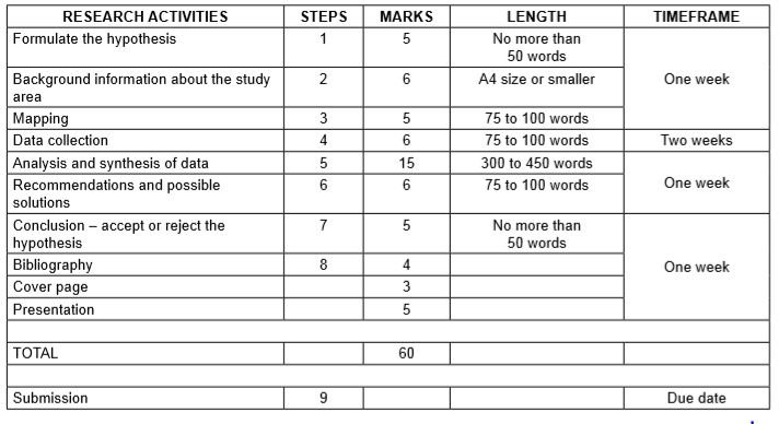
4.2 Term 3 – Research task Two examples of typical research tasks are provided below. 4.2.1 Learner guidelines for conducting research Research framework for assessment (Guideline on administration of research task)
|
|
|
|
|
Formulate the hypothesis/Problem statement | 1 | 5 | 50 words No more than | One week |
Background information about the study area | 2 | 6 | 75 to 100 words | |
Mapping | 3 | 5 | A4 size or smaller | |
Data collection | 4 | 6 | 75 to 100 words | Two weeks |
Analysis and synthesis of data | 5 | 15 | 300 to 450 words | One week |
Recommendations and possible solutions | 6 | 6 | 75 to 100 words | |
Conclusion – accept or reject the hypothesis | 7 | 5 | 50 words No more than | One week |
Bibliography | 8 | 4 | ||
Cover page | 3 | |||
Presentation | 5 | |||
| 60 | |||
Submission | 9 | Due date |
In choosing a topic for research, isolate topics in specific areas in the Geography CAPS content that you have studied in Grade 12.
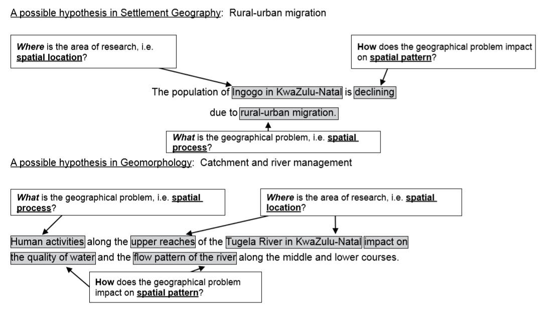
4.2.2 Guidelines for research Research Task Step 1: Formulating a hypothesis/problem statement As Geographers we seek to understand and explain the interactions amongst humans, and between humans and the environment in space and time. This is achieved by asking questions or making informed geographical decisions. This entails the development of a hypothesis or a problem statement to be tested.
- You have to choose a specific area of study where a geographical problem exists.
- During this stage, a geographical question showing a problem is asked.
- Identify the problem from a local area.
- Formulate a hypothesis or a problem statement. (Hypothesis research is used to prove that certain variables are dependent on or independent of each other. Problem statement research is only to highlight that a specific problem exists in a specific community.)
- You should then follow the steps of research to ensure that the geographical question is answered.
Other possible hypothesis-type research examples:
- The value of property along north-facing slopes is higher than the value of property along south-facing slopes in Meyersdal, Gauteng (choose local area).
- The cause of rural-urban migration in Ndwedwe, KwaZulu-Natal (choose local area), is the lack of service delivery in the health sector.
- Climate change will impact negatively on grape farming and related industries in the Western Cape.
- The closing down of many primary schools in Lusikisiki (Eastern Cape) (choose a local area) is due to a decline of the population in the age group 7 to 15 years.
- The poor condition of roads (specify the names of the roads) leading to/in Harrismith, Free State (choose local area), is due to the lack of proper planning by the local municipality.
- The impact of building a dam along the Jukskei River in Gauteng (choose local area) upstream of Alexandra will reduce flooding and the subsequent loss of life in Alexandra.
- The e-toll system will impact negatively on the economic position of people using private transport in Gauteng.
- The e-toll system will impact positively on traffic flow to the major urban centres in Gauteng.
- Informal settlements in the Vhembe district of Limpopo have low levels of development due to the lack of provision of basic needs (choose ONE informal settlement in your local area).
- Overcrowding of informal settlements is due to the lack of proper planning by the local government (choose local area).
Step 2: Background information about an area of study
- You must explain where in South Africa the study area is located. (This can be indicated on the map.)
- Describe the study area in terms of its exact position (degrees, minutes and seconds).
- Provide relevant information about the area, for example population of the area or climate of the area.
Step 3: Mapping
- You must provide a map of the area in question.
- During this stage you must create a buffer zone around the area where the geographical problem exists.
- The map should have a clear legend/key and must be drawn to scale. The scale must be indicated on the map.
- If the map used covers a wider area, buffer zones around the area of study should be created.
- The map used should be the most recent map of the study area.
Step 4: Methods of data collection
- The use of questionnaires
- Observations
- Field trips
- Newspaper articles
- Government department statistics
Step 5: Analysis and synthesis of data
- Use collected data now to formulate a discussion around the existing geographical problem.
- At this stage you should represent some of the information graphically where necessary, for example graphs and sketches.
- Analyse graphic information during this stage.
Step 6: Recommendations and possible solutions
- You should now make recommendations to solve the geographical problem in question.
- You should present your original and realistic opinions as far as you possibly can.
Step 7: Conclusion – accept or reject the hypothesis
- You should now take a decision to either ACCEPT or REJECT the hypothesis.
- Give reasons for either ACCEPTING or REJECTING the hypothesis.
Step 8: Bibliography
- You must include a comprehensive bibliography.
- List websites in full.
- You must include annexures of questionnaires and interviews conducted.
Step 9: Submission
- You must include graphs, tables, diagrams and pictures where necessary.
- On submission, ensure that a suitable cover page is included.
4.2.3 Compiling a bibliography for a research task
- For a book: Author (last name, initials). Title of Book (Publishers, Date of publication). Example: Dahl, R. The BFG. (Farrar, Straus & Giroux, 1982).
- For an encyclopaedia: Encyclopaedia Title , Edition date. Volume number, ˈArticle Titleˈ, page number(s). Example: Encyclopaedia Britannica , 1997. Volume 7, ˈGorillasˈ, pp. 50–51.
- For a magazine: Author (last name first), ˈArticle Titleˈ. Name of Magazine . Volume number, (Date): page number(s). Example: Jordan, Jennifer, ˈFilming at the Top of the Worldˈ. Museum of Science Magazine . Volume 47, No. 1, (Winter 1998): p. 11.
- For a newspaper: Author (last name first), ˈArticle Titleˈ. Name of Newspaper. City, state publication. (Date): Edition if available, Section, page number(s). Example: Powers, Ann, ˈNew Tune for the Material Girlˈ. The New York Times . New York, NY. (3/1/98): Atlantic Region, Section 2, p. 34.
- For a website: Quote the name of the website in full and underline. Example: http://www.sahistory.org.za/topic/womens-struggle-1900-1994
- For a person: Full name (last name first). Occupation, date of interview. Example: Smeckleburg, Sweets. Bus driver. 1 April 1996.
- For a film/documentary: Title, Director, Distribution, Year. Example: Braveheart, Director Mel Gibson, Icon Productions, 1995.
4.2.4 Proposed cover page for a research task
| |
| |
| |
| |
| |
| |
STATEMENT OF AUTHENTICITY I hereby declare that ALL pieces of writing contained in this research task are my own original work and that if I made use of any source, I have duly acknowledged it.
Learner’s signature: __________________________________ Date: _____________
4.2.5 Exemplar: Research task 1
- Curriculum content: Key human-environment interactions in urban areas: People and places – inner-city problems
- One (1) research task must be done.
South African cities attract thousands of new residents every year in search of work and a better life. The housing shortage, along with a shortage of housing subsidies, means that for many South Africans there is no alternative but to live in informal housing and shack settlements. The rapid increase in informal settlements around the cities in South Africa has resulted in an increase in crime rates in the inner city. |
Compile your research by completing the activities outlined below.
Step 1: Formulate the hypothesis/problem statement
- Formulate your own hypothesis based on a problem you have identified, for example: The increasing number of informal settlements (choose localised informal settlement) in and around urban areas in South Africa has resulted in higher crime rates within the inner city due to higher unemployment. (Focus: More people in surrounding informal settlements result in unemployment causing people to turn to crime.)
Step 2: Background information about the study area Give a brief introduction and description (background information) of the city (study area) you have selected in terms of:
- Historical background
- Population
- Description of the location of informal settlements in relation to the inner city
- Other relevant statistical information
- Provide a map showing the position of the informal settlement in relation to the city that you have identified for your research task. (It is easier to choose your local area as an area of study.)
- The map should clearly indicate buffer zones where informal settlements are located.
- The map should include areas of the city that are regarded as crime ˈhotspotsˈ.
- The map must have a clear legend/key.
- The scale of the map must be indicated.
Step 4: Data collection Collect data using at least THREE methods, for example:
- Questionnaires
- Interviews
- Field trips
- Photographs and maps
- Literature research (newspapers, magazines, books, et cetera)
- Internet research
- Analyse the data that you have collected, and formulate a report on your findings. Support your findings with graphs, photos, et cetera.
- Briefly discuss how the existence of informal settlements contributes to crime in the inner city.
- Briefly discuss the contribution of high unemployment rates in the informal settlement to crime in the inner city.
Step 6: Recommendations and solutions
- Provide suitable recommendations and solutions to the problem.
Step 7: Conclusion – accept or reject the hypothesis
- Based on your findings in Step 5, you may either ACCEPT or REJECT the hypothesis.
- Give reasons for your conclusion.
- Compile a bibliography for your research. If you have done any Internet research, you must provide the website(s) that you have used in full.
- Collate all your information.
- Include a table of contents.
- Ensure that you include a copy of the questionnaire and/or questions asked in your interviews as annexures.
- Design a suitable cover sheet.
- Submit your research.
4.2.6 Exemplar: Research task 2
- Curriculum content: Physical Geography (fluvial processes)
Rivers obtain water from surface run-off and ground water of their drainage basins. Activities taking place in the drainage basin affect the quality of water in the river. |
Choose a river close to your school or where you live as an area of study, and conduct your research by following the steps outlined below. Step 1: Formulate the hypothesis/problem statement
- Formulate your own hypothesis based on a problem you have identified, for example:
Human activities impact negatively on the quality of water and the flow pattern in the upper reaches/course of the Blood River in Limpopo. |
Step 2: Background information about the river under study
- Describe the provincial location of the river.
- Climate – particularly the amount of rainfall that is received.
- Vegetation
- Relief and topography
- Underlying rock structure
- Specify the river type, for example permanent, periodic.
- Describe the river stage (youth, mature or old age) at your study area.
- Provide a map showing the river being studied and the adjacent settlements.
- Create a clear buffer zone at the part of the river that is being studied.
- The map should have a clear key/legend.
- Indicate the scale of the map.
- Use the above sets of data collected to determine the extent to which the river is affected by human activities.
- Explain in detail how the identified human activities impact on the quality of water and the flow pattern of the river.
Step 6: Recommendations and solutions
- In your opinion as a researcher, what would be the possible solution(s) to the negative impact caused by human activities in the river?
- Make long-term recommendations to the government department(s) leading to legislature to protect the river.
Step 7: Conclusion – accept or reject the hypothesis
- Submit your research.
4.2.7 Proposed marking rubric for a research task
NAME OF LEARNER: _________________________________________________________GRADE: __________
CURRICULUM TOPIC: __________________________________________________________________________
RESEARCH TOPIC: __________________________________________________________________________
|
|
|
|
| ||||
| ||||||||
|
|
|
|
|
| |||
| ||||||||
|
|
|
|
|
|
| ||
| . | |||||||
| ||||||||
| ||||||||
| on | ||||||||
EDUCATOR NAME: ______________________________DATE OF ASSESSMENT: __________________
MODERATOR NAME: ______________________________DATE OF MODERATION: __________________
5. CONCLUSION This document provides you with a framework to develop your own research task. It also provides you with a framework of expectancy for data-handling tasks. The framework for data-handling tasks can also be used to prepare for external examinations where data-handling-type questions can be asked. A clear guideline has been developed on how to conduct research. This guideline can be applied to any topic within the CAPS in which you wish to conduct research. The marking rubric that has been included will also provide you with a clear guide on the time that should be spent on the various phases of doing research. The high standard of these tasks will provide a platform for you to develop skills such as research, interpretation of resources, integration of resources and graphs, all skills required for the final external Geography examination. These are also skills that can be put to use at a later stage in your life.
Related items
- Mathematics Grade 12 Investigation 2023 Term 1
- TECHNICAL SCIENCES PAPER 2 GRADE 12 QUESTIONS - NSC PAST PAPERS AND MEMOS JUNE 2022
- TECHNICAL SCIENCES PAPER 1 GRADE 12 QUESTIONS - NSC PAST PAPERS AND MEMOS JUNE 2022
- MATHEMATICS LITERACY PAPER 2 GRADE 12 MEMORANDUM - NSC PAST PAPERS AND MEMOS JUNE 2022
- MATHEMATICS LITERACY PAPER 2 GRADE 12 QUESTIONS - NSC PAST PAPERS AND MEMOS JUNE 2022
GEOGRAPHY GRADE 12 RESEARCH TASK 2018
- Download HTML
- Download PDF

- Health & Fitness

- Current Events

- Uncategorized

- Hobbies & Interests

- Government & Politics

- IT & Technique

- Cars & Machinery

- Home & Garden

- World Around

- Arts & Entertainment

- How It Works
- PhD thesis writing
- Master thesis writing
- Bachelor thesis writing
- Dissertation writing service
- Dissertation abstract writing
- Thesis proposal writing
- Thesis editing service
- Thesis proofreading service
- Thesis formatting service
- Coursework writing service
- Research paper writing service
- Architecture thesis writing
- Computer science thesis writing
- Engineering thesis writing
- History thesis writing
- MBA thesis writing
- Nursing dissertation writing
- Psychology dissertation writing
- Sociology thesis writing
- Statistics dissertation writing
- Buy dissertation online
- Write my dissertation
- Cheap thesis
- Cheap dissertation
- Custom dissertation
- Dissertation help
- Pay for thesis
- Pay for dissertation
- Senior thesis
- Write my thesis
146 Impressive Geography Research Topics Every Student Will Like

Are you a student seeking inspiration for your next geography research project? Look no further! In this article, we present you with a treasure trove of 146 original and top-quality geography research topics, completely free of charge. Whether you’re pursuing a degree in geography or simply passionate about exploring the world around you, these topics cover a wide range of fascinating subjects.
From human geography and cultural landscapes to physical geography and environmental sustainability, we’ve got you covered. Each topic is carefully crafted to ignite your curiosity and help you delve deeper into the field. Get ready to embark on an exciting journey of exploration and discovery as you uncover unique research ideas that will captivate both you and your readers.
Areas Of Geography
Geography is a field of study that explores the Earth’s physical features, human activities and their interactions. It examines the spatial patterns, processes, and relationships between the environment and society. Geographers investigate the Earth’s surface, analyzing its landscapes, climate, ecosystems and resources, as well as the distribution of populations, cultures, economies, and political systems. There are several types of geography, each focusing on specific aspects of the Earth’s physical and human dimensions:
Physical geography examines natural phenomena like landforms, weather and ecosystems. Human geography studies human activities, such as population distribution, urbanization and cultural landscapes. Economic geography explores the spatial patterns of economic activities, trade and resource distribution. Political geography analyzes the political systems, boundaries and geopolitical relationships between regions. Environmental geography investigates the interactions between humans and the environment, including environmental issues and sustainability. Geographical information systems (GIS) and remote sensing employ technology to analyze spatial data and maps.
These subfields together provide a comprehensive understanding of the Earth’s complexities and its relationship with human society.
Easy Geography Research Paper Topics
Want to write your paper in just a couple of hours? Explore a curated list of accessible and easy geography research paper topics that will make your geography research paper writing a breeze:
- The impact of climate change on coastal regions
- Exploring the relationship between geography and tourism
- Analyzing urbanization trends in developing countries
- Investigating the effects of deforestation on biodiversity
- Examining the role of geography in natural disaster management
- Studying the cultural landscape of a specific region
- Analyzing the geography of food production and distribution
- Exploring the impact of transportation on urban development
- Investigating the geography of renewable energy sources
- Analyzing the spatial patterns of population growth
- Studying the impact of globalization on local economies
- Examining the geography of water resources and management
Human Geography Research Topics
Improve your chances of getting a top grade! Delve into the complex interplay between humans and their environment with this comprehensive list of human geography research topics:
- Exploring the social implications of gentrification in urban areas
- Analyzing the influence of gender on migration patterns
- Investigating the impact of globalization on cultural identity
- Examining the geography of poverty and social inequality
- Studying the relationship between health and geographical location
- Analyzing the spatial distribution of ethnic communities in cities
- Investigating the geography of political power and governance
- Exploring the role of geography in shaping human behavior
- Analyzing the impacts of urban sprawl on communities
- Studying the geography of education access and quality
- Examining the spatial patterns of crime and its socio-economic factors
- Investigating the geography of healthcare provision and disparities
Cultural Geography Research Topics
Interested in cultural geography? Immerse yourself in the rich tapestry of cultures and their geographical influences with this captivating list of cultural geography research topics:
- Analyzing the cultural landscapes of indigenous communities
- Exploring the impact of globalization on cultural diversity
- Investigating the geography of language and its preservation
- Examining the influence of religion on cultural landscapes
- Studying the role of cultural heritage in tourism development
- Analyzing the geography of cultural festivals and events
- Investigating the spatial patterns of cultural diffusion
- Exploring the impact of migration on cultural identities
- Analyzing the geography of music and its regional variations
- Investigating the role of food culture in shaping identities
- Examining the spatial distribution of cultural institutions
- Studying the geography of art and its impact on communities
Physical Geography Research Topics
Do you want to write about physical geography? Investigate the natural processes and phenomena shaping our planet through this collection of compelling physical geography research topics:
- Analyzing the processes of coastal erosion and their impacts
- Investigating the formation and characteristics of river systems
- Examining the effects of climate change on glacial landscapes
- Analyzing the spatial patterns of soil erosion and conservation
- Investigating the biogeography of specific ecosystems
- Exploring the impacts of climate on vegetation patterns
- Analyzing the geography of water resources and hydrology
- Investigating the formation and classification of landforms
- Examining the spatial distribution of biodiversity hotspots
- Studying the interactions between humans and the natural environment
- Exploring the impacts of urbanization on natural landscapes
Geography Thesis Topics
Are you busy planning your thesis? Engage in an in-depth exploration of geographic concepts and theories with this thought-provoking list of geography thesis topics:
- Investigating the geographical aspects of sustainable development
- Analyzing the impacts of climate change on vulnerable communities
- Exploring the role of geography in disaster risk reduction
- Studying the geography of migration and refugee movements
- Examining the relationship between urban planning and social equity
- Analyzing the spatial patterns of energy consumption and renewable solutions
- Exploring the geographical dimensions of political conflicts and peacebuilding
- Investigating the role of geography in land use planning and conservation
- Examining the impacts of globalization on local economies
Urban Geography Thesis Topics
Are you interested in writing about urban geography? Analyze the complexities of urban landscapes and urbanization processes with this curated selection of urban geography thesis topics:
- Analyzing the effects of gentrification on urban neighborhoods
- Investigating the role of urban design in creating sustainable cities
- Examining the spatial patterns of urban sprawl and its consequences
- Studying the geography of social segregation in urban areas
- Analyzing the impacts of transportation systems on urban mobility
- Investigating the relationship between urbanization and public health
- Exploring the geography of informal settlements and slums
- Analyzing the impacts of urban green spaces on quality of life
- Investigating the geography of urban food systems and food security
- Examining the role of technology in shaping smart cities
- Studying the spatial distribution of cultural and recreational amenities in cities
PhD Research Topics In Geography
Expand the boundaries of geographical knowledge and contribute to the field with this diverse and stimulating list of PhD research topics in geography:
- Analyzing the geography of environmental justice in urban areas
- Investigating the impacts of climate change on indigenous communities
- Examining the role of geography in disaster risk governance
- Studying the spatial patterns of land use change in rapidly urbanizing regions
- Analyzing the impacts of transportation infrastructure on accessibility and equity
- Investigating the geographical dimensions of health inequalities
- Exploring the relationship between globalization and urbanization processes
- Analyzing the geography of political conflicts and territorial disputes
- Investigating the impacts of natural resource extraction on local communities
- Studying the spatial dynamics of international migration and its consequences
- Exploring the geography of innovation and knowledge economies in cities
Captivating Research Topics In Geography
Looking for some captivating research topics in geography? Ignite curiosity and scholarly interest with this awesome collection of research topics that delve into various aspects of geography:
- Investigating the geography of mega-cities and their challenges
- Analyzing the impacts of climate change on vulnerable coastal regions
- Exploring the spatial patterns of cultural landscapes and heritage sites
- Studying the geography of borderlands and transnational interactions
- Examining the impacts of tourism on local communities and environments
- The role of geography in understanding human-environment interactions
- Analyzing the spatial distribution of environmental pollution and its impacts
- Exploring the geography of global food systems and agricultural practices
- Investigating the impacts of natural disasters on urban resilience
- Examining the role of geography in understanding urban inequalities
- Studying the geography of geopolitical conflicts and their implications
- Exploring the impacts of technological advancements on landscapes
Interesting Geography Research Topics
Discover a wide range of interesting geography research topics that will pique your professor’s curiosity and offer new insights into the world of geography:
- Analyzing the impacts of climate change on glacier retreat and water resources
- Investigating the geography of renewable energy transition and its challenges
- Examining the spatial patterns of urban heat islands and their mitigation strategies
- Studying the impacts of land use change on biodiversity conservation
- Investigating the role of geography in understanding cultural diversity
- Exploring the geography of disease outbreaks and their spatial spread
- Investigating the impacts of natural hazards on human vulnerability and resilience
- Examining the spatial distribution of ecological corridors
- Studying the geography of regional economic disparities and development strategies
- Exploring the impacts of transportation infrastructure on urban accessibility
- The role of geography in understanding weather patterns
Good Geography Research Topics For 2023
Looking for some current topics to write about? Choose from a list of good geography research topics for 2023 that showcase the relevance and significance of geography in today’s world:
- Impacts of population growth on urban infrastructure and services in geography
- Geography of water scarcity and its implications for communities
- Spatial patterns of environmental conservation and protected areas in geography
- Impacts of land degradation on agricultural productivity and food security
- Geography of natural resource management and sustainable practices
- Relationship between climate change and human migration patterns in geography
- Spatial distribution of environmental justice and marginalized communities
- Impacts of urbanization on water pollution and ecosystem degradation
- Geography of renewable energy sources and their integration into the grid
- Role of geography in understanding regional conflicts over natural resources
- Impacts of deforestation on biodiversity loss and ecosystem services
Geography Topics For Research For College
Need some great geography topics for research for college? Explore a comprehensive list of geography research topics tailored for college-level studies, offering opportunities for critical analysis and exploration:
- Impacts of transportation infrastructure on urban air quality in geography
- Geography of urban gentrification and displacement
- Spatial patterns of urban food waste and its environmental consequences
- Impacts of tourism development on fragile ecosystems in geography
- Geography of environmental migration and its social implications
- Role of geography in understanding climate adaptation strategies
- Spatial distribution of environmental inequalities and environmental racism
- Impacts of land use change on water quality in agricultural regions
- Geography of geopolitical conflicts and territorial disputes
- Impacts of industrial pollution on urban health and well-being
- Role of geography in understanding disaster preparedness
Interesting Geography Topics For High School
Get the most interesting geography topics for high school. Foster geographical curiosity and critical thinking skills with this intriguing list of essay topics designed specifically by our best dissertation service writers for high school students:
- Analyzing the impacts of climate change on the polar regions
- Investigating the geography of natural hazards
- Examining the spatial distribution of endangered species
- Studying the impacts of urbanization on wildlife habitat fragmentation
- Exploring the geography of cultural diversity and multiculturalism in cities
- Investigating the role of geography in understanding climate variability
- Analyzing the spatial patterns of population distribution and density
- Investigating the geography of international migration and refugee flows
- Examining the impacts of tourism on local communities and cultures
- Studying the geography of natural resources
- Exploring the role of geography in understanding global inequality
Engaging Geographical Research Topics
Embark on a captivating journey of geographical exploration with this diverse collection of engaging geographical research topics, connecting people, places and the environment through insightful investigations:
- Urban sprawl impacts on land use and ecosystem services in geography
- Geography of renewable energy transition and its challenges
- Spatial patterns of urban heat islands and impacts on residents
- Impacts of climate change on coastal erosion and shoreline management
- Geography of water scarcity and implications for human populations
- Role of geography in understanding geopolitical conflicts and peacebuilding
- Spatial distribution of environmental pollutants and health effects
- Impacts of globalization on local economies and cultural landscapes
- Geography of gender inequalities and spatial dimensions
- Impacts of natural disasters on vulnerable communities and recovery
- Role of geography in understanding migration dynamics and urbanization
- Geography of political borders and their social and economic implications
Affordable Thesis Help You Can Rely On
When it comes to working on a geography research paper or a thesis for Master’s degree , our company is your trusted source for comprehensive writing help. Our team of expert writers consists of experienced professionals who specialize in geography, ensuring that you receive top marks for your school or class. We pride ourselves on delivering high quality and impressive custom written theses tailored to your specific requirements.
With our secure and fast online service, you can access thesis help that is not only affordable but available 24/7. Rest assured that your work will be handled by native English-speaking experts (ENL writers), guaranteeing exceptional quality and adherence to academic standards. Trust us for all your thesis needs and achieve academic success with ease.
Make sure to check our posts with other topics before you leave:
- 122 Best Ecology Topics To Sparkle Your Writing
- 195 Top Anthropology Topics For Great Thesis
- 170 Fantastic Astronomy Topics For High Scoring Tests
Why is choosing a great topic important when writing a geography essay?
Choosing a great topic ensures that your essay is engaging, relevant, and allows you to demonstrate your understanding of key geographical concepts while capturing the reader’s interest.
How can I choose a great topic for my geography essay?
To choose a great topic, consider current geographical issues, areas of personal interest and the availability of reliable sources. Additionally, ensure that the topic aligns with your essay’s objectives and requirements.
What are some strategies for narrowing down a geography essay topic?
To narrow down your topic, focus on specific geographical regions, phenomena, or concepts. Consider exploring the intersections between different aspects of geography, such as human and physical geography, to create a unique and well-rounded essay topic.
Can I get assistance in choosing a great topic for my geography essay?
Yes, you can seek guidance from your instructor, consult reputable academic resources or utilize online platforms that provide topic suggestions. Engaging in discussions with peers or experts in the field can also help generate ideas and refine your topic choice.

Leave a Reply Cancel reply
Your email address will not be published. Required fields are marked *
Comment * Error message
Name * Error message
Email * Error message
Save my name, email, and website in this browser for the next time I comment.
As Putin continues killing civilians, bombing kindergartens, and threatening WWIII, Ukraine fights for the world's peaceful future.
Ukraine Live Updates
Grade 12 Geography
Geography grade 12 research tasks (topics) and memos (sba).
Geography Grade 12 Research Tasks (Topics) and Memos for: term 1, Term 2, Term 3 and Term 4
Assessment is a continuous planned process of identifying, gathering and interpreting information about the performance of learners, using various forms of assessment. It involves four steps: generating and collecting evidence of achievement; evaluating this evidence; recording the findings and using this information to understand and assist with the learners’ development to improve the process of learning and teaching. Assessment should be both informal (assessment for learning) and formal (assessment of learning). In both cases regular feedback should be provided to learners to enhance the learning experience.
School-based assessment (SBA) is a purposive collection of learners’ work that tells the story of learners’ efforts, progress or achievement in given areas. The quality of SBA tasks is integral to learners’ preparation for the final examinations.
This booklet serves as a resource of four exemplar SBA tasks to schools and subject teachers of Geography. SBA marks are formally recorded by the teacher for progression and certification purposes. The SBA component is compulsory for all learners. Learners who cannot comply with the requirements specified according to the policy may not be eligible to enter for the subject in the final examination.
The formal assessment tasks provide the teacher with a systematic way of evaluating how well learners are progressing. This publication includes tests, a project and a case study. Formal assessment tasks form part of a year-long formal programme of assessment. These tasks should not be taken lightly and learners should be encouraged to submit their best possible efforts for final assessment.
The teachers are expected to ensure that assessment tasks are relevant to and suitable for the learners being taught. Teachers should adapt the tasks to suit learners’ level of understanding and should be context-bound; however, they should also take cognisance of the requirements as set out in the Curriculum and Assessment Policy Statement (CAPS) document.
- 1 What Skills are Assessed for Research Tasks in Grade 12
- 2.0.1 Guideline: Geography Grade 12 Research Tasks
- 2.1 Geography Research Project Topics for Grade 12 South Africa
- 3 Step 2: Background information about an area of study
- 4 Step 3: Mapping
- 5 Step 4: Methods of data collection
- 6 Step 5: Analysis and synthesis of data
- 7 Step 6: Recommendations and possible solutions
- 8 Step 7: Conclusion – accept or reject the hypothesis
- 9 Step 8: Bibliography
- 10 More Geography Grade 12 Resources
- 11 Mid Latitude Cyclones Notes Grade 12
- 12 Geography Grade 12 2019 Exam Papers and Memos
- 13 Geography Grade 12 2020 Past Papers and Memos
- 14 Geography Grade 12 Research Tasks (Topics) and Memos (SBA)
- 15 Grade 12 Geography Exam Papers and Memos for 2019 September and November
- 16 Geography Mind the Gap study guide: Grade 12 Download
What Skills are Assessed for Research Tasks in Grade 12
The following skills are assessed. Some/All of these skills may be tested in any external examination:
- Gathering data
- Interpreting data
- Analysing data
- Comparing different sets of data
- Representing data in written, graphic or mapped format
- Problem-solving
- Drawing conclusions
- Hypothesis statements
Research framework for assessment (Guideline on administration of research task)
Step 1: Formulating a hypothesis/problem statement.
Guideline: geography grade 12 research tasks.
Step 1: Formulating a hypothesis/problem statement. As Geographers we seek to understand and explain the interactions amongst humans, and between humans and the environment in space and time. This is achieved by asking questions or making informed geographical decisions. This entails the development of a hypothesis or a problem statement to be tested.
- You have to choose a specific area of study where a geographical problem exists.
- During this stage, a geographical question showing a problem is asked.
- Identify the problem from a local area.
- Formulate a hypothesis or a problem statement. (Hypothesis research is used to prove that certain variables are dependent on or independent of each other. Problem statement research is only to highlight that a specific problem exists in a specific community.)
- You should then follow the steps of research to ensure that the geographical question is answered.
Geography Research Project Topics for Grade 12 South Africa
- The value of property along north-facing slopes is higher than the value of property along south-facing slopes in Meyersdal, Gauteng (choose local area).
- The cause of rural-urban migration in Ndwedwe, KwaZulu-Natal (choose local area), is the lack of service delivery in the health sector.
- Climate change will impact negatively on grape farming and related industries in the Western Cape.
- The closing down of many primary schools in Lusikisiki (Eastern Cape) (choose a local area) is due to a decline of the population in the age group 7 to 15 years.
- The poor condition of roads (specify the names of the roads) leading to/in Harrismith, Free State (choose local area), is due to the lack of proper planning by the local municipality.
- The impact of building a dam along the Jukskei River in Gauteng (choose local area) upstream of Alexandra will reduce flooding and the subsequent loss of life in Alexandra.
- The e-toll system will impact negatively on the economic position of people using private transport in Gauteng.
- The e-toll system will impact positively on traffic flow to the major urban centres in Gauteng.
- Informal settlements in the Vhembe district of Limpopo have low levels of development due to the lack of provision of basic needs (choose ONE informal settlement in your local area.)
- Overcrowding of informal settlements is due to the lack of proper planning by the local government (choose local area).
Step 2: Background information about an area of study
- You must explain where in South Africa the study area is located. (This can be indicated on the map.)
- Describe the study area in terms of its exact position (degrees, minutes and seconds).
- Provide relevant information about the area, for example population of the area or climate of the area.
Step 3: Mapping
- You must provide a map of the area in question.
- During this stage you must create a buffer zone around the area where the geographical problem exists.
- The map should have a clear legend/key and must be drawn to scale. The scale must be indicated on the map.
- If the map used covers a wider area, buffer zones around the area of study should be created.
- The map used should be the most recent map of the study area
Step 4: Methods of data collection
(a) PRIMARY DATA SOURCES
- The use of questionnaires
- Observations
- Field trips
(b) SECONDARY DATA SOURCES
- Newspaper articles
- Government department statistics
Step 5: Analysis and synthesis of data
• Learners must use collected data now to formulate a discussion around the existing geographical problem. • At this stage learners should represent some of the information graphically where necessary, for example graphs and sketches. • Learners must analyse graphic information during this stage.
Step 6: Recommendations and possible solutions
• Learners should now make recommendations to solve the geographical problem in question. • Learners should present their original and realistic opinions as far as they possibly can.
Step 7: Conclusion – accept or reject the hypothesis
- Learners should now take a decision to either ACCEPT or REJECT the hypothesis.
- Learners must give reasons for either ACCEPTING or REJECTING the hypothesis
Step 8: Bibliography
- Learners must include a comprehensive bibliography.
- Learners must list websites in full.
- Learners must include annexures of questionnaires and interviews conducted
More Geography Grade 12 Resources
- Geography 2020 Past Papers
- Geography 2019 Past Papers
Grade 12 Geography Exam Papers and Memos for 2019 September and November
- Geography Grade 12 Research Tasks (Topics) and Memos

Mid Latitude Cyclones Notes Grade 12

- March 24, 2021

Geography Grade 12 2019 Exam Papers and Memos
- February 28, 2021

Geography Grade 12 2020 Past Papers and Memos

- February 22, 2021

- September 29, 2020
Geography Mind the Gap study guide: Grade 12 Download
- August 17, 2020
Read All Posts
Geography Grade 12 2020 Past Papers and Memos for study revision
You may like
Your email address will not be published. Required fields are marked *
Save my name, email, and website in this browser for the next time I comment.
Download Geography Grade 12 September 2020 Past Papers and Memos
Geography Grade 12 September 2020 Past Papers and Memos paper 1 and paper 2 pdf download
List of Geography Grade 12 September 2020 Past Papers and Memos
Geography grade 10, main reasons why is south africa regarded as a developing country.
Reasons why is South Africa regarded as a developing country: South Africa has a great economic infrastructure and natural resources that characterize its economy. In South Africa, there is outstanding progress in the field of industry and manufacturing. South Africa, however, is still characterised as a developing country and not a developed country.
- 0.1 6 Characteristics of a Developed Country
- 0.2 5 Reasons why is South Africa regarded as a developing country
6 Characteristics of a Developed Country
1. Has a high income per capita. Developed countries have high per capita incomes each year. By having a high income per capita, the country’s economic value will be boosted. Therefore, the amount of poverty can be overcome.
2. Security Is Guaranteed. The level of security of developed countries is more secure compared to developing countries. This is also a side effect of sophisticated technology in developed countries. With the sophisticated technology, security facilities and weapons technology also develop for the better.
3. Guaranteed Health. In addition to ensuring security, health in a developed country is also guaranteed. This is characterized by a variety of adequate health facilities, such as hospitals and medical staff who are trained and reliable.
4. Low unemployment rate. In developed countries, the unemployment rate is relatively small because every citizen can get a job and work.
5. Mastering Science and Technology. The inhabitants of developed countries tend to have mastered science and technology from which new useful products such as the industrial pendant lights were introduced to the market. Therefore, in their daily lives, they have also used sophisticated technology and modern tools to facilitate their daily lives.
6. The level of exports is higher than imports. The level of exports in developed countries is higher than the level of imports because of the superior human resources and technology possessed.
5 Reasons why is South Africa regarded as a developing country
1. South Africa has a low Income per year. Annual income in developing countries is not as high as in developed countries due to the high unemployment rate.
2. In South Africa, security is not guaranteed. Unlike in developed countries, security in developing countries is still very minimal and inappropriate. Therefore, crime rates in developed countries such as South Africa tend to be relatively high.
3. South Africa has a fast-growing population . According to the World Population Review , South Africa’s population will continue to grow until 2082, reaching just over 80 million people before plateauing and slightly declining the rest of the century. South Africa’s population growth rate is currently 1.28% per year. Developing countries have a very large average population compared to developed countries because of uncontrolled population development. This is also a result of the lack of education and health facilities.
4. The unemployment rate in South Africa is high. South Africa has an unemployment rate of 34.4% in the second quarter of 2021. In developing countries, the unemployment rate is still relatively high because the available job vacancies are not evenly distributed. In addition, the level of uneven education is also one of the factors causing the large unemployment rate.
5. Imports are higher than exports. Due to the low management of natural resources and human resources in developing countries, developing countries more often buy goods from abroad. To eliminate the barriers of being a developed country, South Africa must reduce imports and must refine and develop its agricultural sector.
Characteristics of Developed and Developing Countries
Why_is_South_Africa_Still_a_Developing_Country
Geography Grade 12 November 2020 Question Papers and for study revision
Geography Grade 12 November 2020 Question Papers and Memos pdf download
List of Geography Grade 12 November 2020 Question Papers and Memos
Describe how Ubuntu fight social challenges
Physical Science Grade 12 Notes pdf for study revision
Diane tsa Setswana le ditlhaloso: downloadable pdf
91 Unique English Speech Topics for Grade 11 | Class 11: Education Resource
Grade 8 ems Exam Questions and Answers
Popular Sesotho Idioms: Maele a Sesotho le Ditlhaloso – English Translations
My Name Poem by Magoleng wa Selepe: Questions and Answers
Life Sciences Practical Tasks Grade 11 SBA for all Terms: Education Resource
Top 100 Geography Project Topics [Updated]

Geography is more than just maps and place names; it’s a dynamic field that studies the Earth’s features, inhabitants, and processes. Geography projects offer an exciting opportunity to delve into various aspects of our world, from physical landscapes to human societies. In this blog, we’ll explore a range of engaging top 100 geography project topics suitable for students and enthusiasts alike.
Benefits of Exploring Geography Project Topics
Table of Contents
Exploring geography project topics offers numerous benefits, including:
- Interdisciplinary Learning: Geography projects often integrate elements from various disciplines such as environmental science, sociology, economics, and technology, fostering a holistic understanding of complex issues.
- Critical Thinking: Engaging with geography topics encourages critical thinking skills as students analyze data, evaluate evidence, and propose solutions to real-world problems.
- Global Awareness: Examining various regions and cultures enables students to develop a more expansive worldview, nurturing empathy and comprehension of a wide range of societies and environments.
- Hands-On Experience: Many geography projects involve fieldwork, mapping, and data collection, providing students with practical experience and skills applicable in both academic and professional settings.
- Environmental Stewardship: Investigating topics like climate change, natural disasters, and sustainable development instills a sense of responsibility towards the environment and encourages environmentally conscious behavior.
- Cultural Appreciation: Exploring cultural geography topics allows students to appreciate the diversity of human cultures, traditions, and practices, promoting respect and tolerance for cultural differences.
- Career Opportunities: Geography projects develop skills highly valued in various fields such as urban planning, GIS analysis, international relations, and sustainable development, opening up diverse career paths for students.
- Personal Growth: Through independent research, problem-solving, and project management, students develop confidence, resilience, and a sense of achievement, contributing to their personal growth and academic success.
Overall, exploring geography project topics not only enhances academic learning but also cultivates skills, knowledge, and attitudes essential for informed citizenship and global engagement.
Top 100 Geography Project Topics: Category Wise
Physical geography project topics.
- Climate Change and Its Impact on Polar Regions
- Analysis of Tropical Rainforest Biomes
- Coastal Erosion and Management Strategies
- The Formation and Impact of Volcanoes
- Desertification: Causes, Effects, and Solutions
- Glacial Retreat and Its Consequences
- Hydrological Cycle and Water Management
- Plate Tectonics and Earthquake Prediction
- Weather Patterns and Climate Variability
- Soil Erosion and Conservation Techniques
Human Geography Project Topics
- Urbanization Trends and Challenges in Developing Countries
- Migration Patterns in Europe: Causes and Impacts
- Cultural Diversity in Urban Settings
- Economic Disparities between Rural and Urban Areas
- Gender Inequality in Access to Resources
- Tourism Development and Its Effects on Local Communities
- Globalization and Its Impact on Indigenous Cultures
- Population Growth and Urban Sprawl
- Political Geography of Border Conflicts
- Sustainable Development Goals and Progress
Geospatial Technology Project Topics
- Geographic Information Systems (GIS) Applications in Environmental Monitoring
- Remote Sensing Techniques for Land Use Mapping
- GPS Technology in Wildlife Tracking and Conservation
- LiDAR Technology for Terrain Mapping
- Spatial Analysis of Crime Patterns
- Mobile Mapping Applications for Disaster Response
- Drone Technology in Geographic Research
- Big Data Analytics for Urban Planning
- Crowdsourced Mapping for Disaster Risk Reduction
- Web Mapping Applications for Public Participation
Regional Geography Project Topics
- Case Study of the Amazon Rainforest: Biodiversity and Conservation
- Comparative Analysis of East Asian Megacities
- Geography of Conflict: The Middle East
- Economic Development in Sub-Saharan Africa
- Environmental Challenges in the Himalayan Region
- Cultural Landscapes of Europe: UNESCO World Heritage Sites
- Political Geography of South America: Border Disputes
- Oceania: Islands, Culture, and Climate Change
- Arctic Region: Resources and Governance
- Caribbean Islands: Tourism and Sustainability
Interdisciplinary Geography Project Topics
- Climate Change Adaptation Strategies in Coastal Communities
- Public Health and Environmental Pollution
- Urban Agriculture and Food Security
- Renewable Energy Potential and Implementation
- Disaster Risk Reduction and Resilience Building
- Indigenous Knowledge and Environmental Management
- Smart Cities: Technology and Sustainability
- Environmental Justice and Equity
- Gender Perspectives in Disaster Management
- Climate Refugees: Challenges and Solutions
Geography Education Project Topics
- The Use of Geospatial Technologies in K-12 Education
- Inquiry-Based Learning in Geography Classrooms
- Fieldwork Techniques for Geography Students
- Integrating Geography into STEM Education
- Geography Awareness Week: Activities and Resources
- Virtual Field Trips for Geography Education
- Story Maps as Educational Tools
- Gamification in Geography Learning
- Outdoor Education and Experiential Learning
- Citizen Science Projects in Geography Education
Environmental Geography Project Topics
- Air Pollution Monitoring and Mitigation Strategies
- Water Scarcity and Water Management Policies
- Waste Management and Recycling Initiatives
- Urban Heat Island Effect and Green Infrastructure
- Deforestation and Reforestation Efforts
- Marine Pollution and Ocean Conservation
- Sustainable Agriculture Practices
- Energy Transition and Renewable Resources
- Biodiversity Conservation in Urban Areas
- Green Building Design and Sustainable Architecture
Social Geography Project Topics
- Gentrification and Neighborhood Change
- Spatial Patterns of Poverty and Social Exclusion
- Health Inequalities and Access to Healthcare
- Gendered Spaces: Women’s Safety and Mobility
- Ethnic Enclaves and Cultural Identity
- Urban Segregation and Housing Policy
- Rural-Urban Migration and Social Integration
- LGBTQ+ Geographies: Space, Place, and Identity
- Ageing Population and Urban Design
- Disability and Accessibility in the Built Environment
Economic Geography Project Topics
- Global Trade Networks and Supply Chains
- Foreign Direct Investment and Economic Growth
- Industrial Clusters and Innovation Hubs
- Informal Economy and Urban Informality
- Tourism and Economic Development
- Agricultural Land Use and Food Systems
- Economic Geography of Natural Resource Extraction
- Economic Resilience and Regional Development
- Global Financial Centers and Urban Economies
- Economic Geography of Post-Industrial Cities
Political Geography Project Topics
- Geopolitics of Energy Resources
- Territorial Disputes in the South China Sea
- Border Walls and Border Security Policies
- Secessionist Movements and Self-Determination
- Refugee Camps and Forced Migration
- Electoral Geography and Gerrymandering
- Colonial Legacies and Post-Colonial Geopolitics
- Geopolitical Implications of Climate Change
- Geopolitics of Cyberspace and Digital Surveillance
- Nationalism and Identity Politics in a Globalized World
Things To Avoid Mistakes In Geography Projects
Avoiding mistakes in geography projects is crucial for ensuring accuracy, reliability, and effectiveness. Here are some common pitfalls to avoid:
- Lack of Clear Research Objectives: Ensure that your project has well-defined research objectives and a clear focus. Unclear goals can lead to confusion and haphazard research.
- Insufficient Background Research: Conduct thorough background research on your topic before diving into the project. Lack of understanding can result in inaccurate interpretations and conclusions.
- Ignoring Methodological Rigor: Follow proper research methods and techniques appropriate for your study. Neglecting methodological rigor can undermine the credibility of your findings.
- Poor Data Quality: Use reliable and up-to-date data sources for your project. Relying on outdated or inaccurate data can lead to flawed analysis and conclusions.
- Misinterpretation of Data: Take care to analyze and interpret your data accurately. Misinterpreting data can lead to erroneous conclusions and undermine the validity of your project.
- Overgeneralization: Avoid making sweeping generalizations based on limited data or observations. Acknowledge the limitations of your study and avoid extrapolating findings beyond their scope.
- Neglecting Spatial Context: Geography projects often involve spatial analysis, so consider the spatial context of your research. Failure to account for spatial relationships can lead to incomplete or misleading conclusions.
- Ignoring Ethical Considerations: Be mindful of ethical considerations in your research, particularly when working with human subjects or sensitive data. Respect confidentiality, privacy, and consent guidelines.
- Inadequate Citation and Attribution: Properly cite and attribute sources for all data, information, and ideas used in your project. Failure to do so can result in accusations of plagiarism and academic misconduct.
- Poor Communication: Clearly communicate your findings, methodology, and conclusions in your project report or presentation. Use appropriate language and visuals to effectively convey your message to your audience.
- Failure to Seek Feedback: Seek feedback from peers, mentors, or advisors throughout the project to identify and address potential issues early on. External perspectives can help improve the quality of your work.
- Procrastination: Avoid procrastination and manage your time effectively throughout the project timeline. Starting early and maintaining a consistent workflow can prevent rushed or incomplete work.
By avoiding these common mistakes and following best practices in geography research, you can ensure the quality and success of your projects.
Geography offers a vast array of intriguing topics for exploration, ranging from physical landscapes to human societies and from traditional fieldwork to cutting-edge technology.
Whether you’re interested in understanding the forces shaping our planet or addressing pressing societal challenges, there are various geography project topics waiting for you to discover and delve into further.
So, grab your maps, data, and curiosity, and embark on a fascinating journey through the diverse and dynamic world of geography. Happy exploring!
Related Posts

Step by Step Guide on The Best Way to Finance Car

The Best Way on How to Get Fund For Business to Grow it Efficiently
- University of Oregon Libraries
- Research Guides
- Knight Library
- Choosing a Topic
- Background Information for Geography Papers
- UO Print Aerial Photography Collection
- Free Online Aerial Photography - Oregon
- Free Online Aerial Photography - USA
- Peer Review Process
- Finding Scholarly/Peer-Reviewed Sources
- Why Cite Your Sources
- Citation Management Tools
Where to get Ideas

- Required and optional course readings
- Conversations with others
- Visiting your professor's office hours
- Consulting with your Librarian
- Inspiration from your environment
Understanding Assignments (Video Tutorial)
This short video from the UNC Writing Center will help you understand how to use your assignment to understand where to begin with a research project.

Check out this tutorial from Arizona State Libraries to get started:
- Developing a Research or Guiding Question
Choosing Your Topic is Research (Video Tutorial)
Watch this short video from NC State University Libraries about choosing a research topic.
Getting Started with Research - Choosing a Topic
Getting started .
- Make sure you understand your assignment ( Link to UNC video tutorial about understanding assignments ). Talk to your professor or graduate assistant if you have any questions.
- Think about your interests. What would you like to spend time learning more about? Look over your course materials and lecture notes for ideas. Write down a list of keywords and phrases that interest you.
- Use a topic ideas database such as CQ Researcher or Opposing Viewpoints in Context (links below). Read current periodicals, browse the internet, and check out reference resources and encyclopedias such as Gale e-books (formerly Gale Virtual Reference Library ).
Databases to help you get started
- Be careful not to pick a topic too narrow or too broad. You might not be able to find enough relevant information or you might be overwhelmed with too much information. As you start your research, you might need to adjust your topic.
- Check out the Research Guide for your subject area, which will include links to helpful resources commonly used by researchers. Our subject specialist librarians create these guides -- contact yours with questions and to get personalized help with your research.
From Topic to Question (Infographic)
This graphic emphasizes how reading various sources can play a role in defining your research topic.
( Click to Enlarge Image )

Text description of "From Topic to Question" for web accessibility
Brainstorming Keywords (Infographic)
You will need to use keywords to search for information online and in library resources. Follow this guidance to identify keywords that will be useful for searching.

Text description of "Brainstorming Keywords" for web accessibility
Selecting the Right Number of Keywords (Video Tutorial)
Check out the video from Kimbel Library to help you locate scholarly journal articles in library databases.
- Selecting the Right Number of Keywords
The video is licensed under a Creative Commons (CC) BY-NC-ND 3.0 license: http://tinyurl.com/2t9all
Pause to Reflect
Step one not only requires that you come up wth a research question or topic that is narrow enough to explore for an undergraduate research paper, but it also requires that you consider what type of information you will need to find in order to answer your research question.
- Is your topic so large you could write a whole book or PhD dissertation on it? If so, you should try to narrow your topic down to something manageable within the time you have and the number of pages or words your instructor is requiring.
- Is your topic so specific that you can't find information about it? Go to step 3 to learn how to search more strategically and broaden your search out a bit.
- Do you need some basic facts, dates, or names of historical people or specific theories? If so, go on to step 2: Find Background Information .
- When you are ready, go to step 3 to learn how and where to search for information on your topic.

Mount Hood reflected in Mirror Lake, Oregon, USA . Image in Public Domain.
- << Previous: Citation Management Tools
- Last Updated: Aug 23, 2024 11:19 AM
- URL: https://researchguides.uoregon.edu/Geography
Contact Us Library Accessibility UO Libraries Privacy Notices and Procedures

1501 Kincaid Street Eugene, OR 97403 P: 541-346-3053 F: 541-346-3485
- Visit us on Facebook
- Visit us on Twitter
- Visit us on Youtube
- Visit us on Instagram
- Report a Concern
- Nondiscrimination and Title IX
- Accessibility
- Privacy Policy
- Find People

- Latest Resources
- Quick Links
Tropical Cyclone Hagibis – Geography Grade 12 Research Task

On this page, we have compiled a general guide for Grade 12 Geography Students who are doing their research on Tropical Cyclone Hagabis.
In exploring the characteristics and implications of Tropical Cyclone Hagibis, this research task explores various aspects of tropical cyclones, their development, impacts, and the mitigative strategies that can be employed to minimize their destructive effects. This analysis provides insightful understanding into the dynamics of such natural disasters, particularly focusing on Tropical Cyclone Hagibis.
Overview of Tropical Cyclone Hagabis:
Tropical Cyclone Hagibis, which struck Japan in October 2019, is remembered as one of the most potent and devastating cyclones to hit the region in recent decades. Rapidly intensifying to a Category 5 super typhoon , Hagibis showcased the catastrophic potential of tropical cyclones, with its development fueled by exceptionally warm ocean temperatures and the release of immense amounts of latent heat. Making landfall on the Izu Peninsula on October 12, the cyclone brought unprecedented rainfall, leading to widespread flooding, landslides, and significant infrastructural damage. Hagibis resulted in the loss of over 80 lives, highlighted the urgent need for effective disaster preparedness and response strategies, and became a focal point for discussions on climate change’s impact on the frequency and intensity of such natural disasters.
Map indicating the path of the tropical cyclone Hagabis
Map indicating the path of the tropical cyclone Hagabis:

Why do tropical cyclones develop in late summer?
Tropical cyclones predominantly develop in late summer due to the elevated sea temperatures that prevail during this period. The warm waters serve as the energy source that fuels the cyclones, facilitating the evaporation of warm, moist air that ascends, cools, and condenses to form storm systems. This process is essential for the genesis and intensification of tropical cyclones.
What is the impact of coriolis force and latent heat on the development of tropical cyclones?
The development of tropical cyclones is significantly influenced by the Coriolis force and the release of latent heat . The Coriolis force, a result of the Earth’s rotation, imparts a rotational motion to the storm, which is crucial for the cyclone’s development. Latent heat, released during the condensation of water vapor in the air, provides the energy that intensifies the storm, contributing to the tropical cyclone’s growth and power.
The stage of development of the Tropical Cyclone Hagibis
Tropical Cyclone Hagibis underwent rapid intensification, evolving from a tropical storm to a Category 5 super typhoon in an exceptionally short period. This stage of development highlights the cyclone’s explosive energy release, attributed to the immense amount of latent heat generated during the condensation process, showcasing the cyclone’s capacity for rapid growth and intensification.
Why can category 1 tropical cyclones be more destructive (damaging) than category 5 tropical cyclones?
Category 1 tropical cyclones can be more destructive than Category 5 cyclones due to several factors, including their speed, trajectory, and the specific areas they impact. A Category 1 cyclone, moving slowly over a densely populated area, can cause extensive damage through prolonged exposure to strong winds and heavy rainfall, leading to significant flooding and infrastructural damage.
How did Tropical Cyclone Hagibis impact the following?
Environment.
Tropical Cyclone Hagibis had a profound impact on the environment, causing extensive flooding and landslides. The environmental degradation included overflowed rivers, soil erosion, and significant damage to natural habitats, disrupting the ecological balance in the affected areas.
The economic ramifications of Hagibis were severe, with widespread damage to infrastructure, residential areas, and the agricultural sector. The cyclone’s destruction led to substantial economic losses, highlighting the need for effective disaster preparedness and recovery strategies.
People/Communities
The impact on people and communities was devastating, with Hagibis causing fatalities, displacements, and extensive damage to homes and community facilities. The cyclone’s effects underscored the vulnerability of communities to such natural disasters and the importance of robust emergency response and support systems.
What precautions can be implemented/ or has been implemented to reduce the impact of Tropical Cyclone Hagibis?
The local government/government of the country.
The government’s response included issuing early evacuation orders, setting up emergency shelters, and investing in meteorological technology to improve storm predictions and responses. These measures were critical in minimizing the cyclone’s impact on affected communities.
The local residents
Local residents were encouraged to engage in preparedness activities, including assembling emergency kits, formulating evacuation plans, and identifying safe shelter locations. Community-level drills and infrastructure reinforcement also played vital roles in enhancing resilience to tropical cyclones.
Evaluating the impact of Global Warming on the frequency (regularity) of tropical cyclones.
Global warming, characterized by rising sea temperatures, is likely to increase the frequency and intensity of tropical cyclones . The enhanced energy and moisture available in a warmer climate contribute to more potent and potentially more frequent tropical storms, raising the risk profile for regions prone to such natural phenomena.
Discussing the path of the tropical cyclone Hagabis
Tropical Cyclone Hagibis, notable for its rapid intensification and devastating impact , traced a path that left a significant imprint on Japan in October 2019 . This section discusses the journey of Hagibis from its formation to its landfall and the aftermath.
Formation and Intensification
Originating from a tropical depression in the Western Pacific Ocean, Hagibis escalated into a super typhoon at an unprecedented rate. Key factors contributing to its rapid growth included exceptionally warm sea temperatures and favorable atmospheric conditions, propelling it to reach Category 5 status. This phase of Hagibis highlights the dynamic and powerful nature of tropical cyclones under conducive environmental conditions.
Movement Towards Japan
As it advanced towards Japan, Hagibis started to show signs of weakening but remained a robust and extensive storm system. The approach of Hagibis was closely monitored, with meteorologists predicting significant impacts due to its size and strength. The anticipation and preparedness for Hagibis underscore the importance of early warning systems in mitigating the effects of such natural disasters.
Landfall and Impact
Making landfall on the Izu Peninsula on October 12 , Hagibis brought with it unprecedented rainfall , leading to widespread flooding , landslides , and considerable infrastructural damage . The severity of Hagibis at landfall demonstrated the destructive potential of tropical cyclones, especially in densely populated regions.
The aftermath of Hagibis was marked by a significant loss of life , with over 80 fatalities reported. The storm’s impact extended beyond immediate physical damage, affecting millions through displacement , power outages , and disrupted transportation networks . The recovery and rebuilding efforts in the wake of Hagibis underscored the resilience of the affected communities and the critical role of efficient disaster response and recovery strategies.
Conclusion/Summary
Tropical Cyclone Hagibis serves as a stark reminder of the destructive power of tropical cyclones and the critical need for comprehensive understanding, preparedness, and mitigation strategies. While natural disasters cannot be entirely prevented, improved preparedness, efficient early warning systems, and community education can significantly mitigate their impacts. Furthermore, addressing global warming’s role in the increasing severity and frequency of tropical cyclones is imperative for safeguarding vulnerable communities in the future.
Looking for something specific?
Related posts, economic geography grade 12 questions and answers.
Economic Geography Grade 12 Questions and Answers: Economic Geography Grade 12 Questions and Answers Refer to FIGURE 3.1 showing models of urban structure. Choose...

What Are the 6 Effects of Desertification?
What Are the 6 Effects of Desertification? The six effects of desertification are: What Are the 6 Effects of Desertification? Desertification is a significant...

Easy Ways to Calculate Magnetic Declination
Easy Ways to Calculate Magnetic Declination: Magnetic declination, also known as magnetic variation, is the angle between magnetic north (the direction the north end...
Grade 12 Geography Research Project about informal sector memo pdf
Grade 12 Geography Research Project about informal sector memo pdf Welcome to Grade 12 Geography Research Project: The Informal Sector in Thohoyandou Example Discover...

Name the plate on either side of the plate boundary that runs along the west coast of South America
The name of the plate on either side of the plate boundary that runs along the west coast of South America The plate boundary...

What is the Highest Mountain in Gauteng
What is the Highest Mountain in Gauteng: The highest mountain in Gauteng is Magaliesberg. This mountain range stretches approximately 120 kilometers from Pretoria through...
Previous Story
Tropical Cyclone Nivar - Geography Grade 12 Research Task
Guide: writing a conclusion for an essay on "why the bantu education act is interesting or important to know about today".
- Rating Count
- Price (Ascending)
- Price (Descending)
- Most Recent
Geography research tasks
Resource type.

Geography Research Task Cards: United States

Africa Scavenger Hunt - Research Task

Halloween Short Research Project: Myths, Ghosts, & Legends Media Presentation

WHERE IN THE WORLD IS WYATT? • A Geography Game of World Capitals

US Geography : Memorize & Research the 50 US States and Capitals (Google Slides)

Australian Map Display and Geography Activities

GERMANY TEACHING RESOURCES - GEOGRAPHY GERMAN LANGUAGE CULTURE COUNTRY HISTORY

1st Grade Geography Activities for Ohio Standards

Cultural Geography Research Projects for 6 - 9 year olds

Library Lessons Task Cards - Research for Biography, Science, and Social Studies

Canada Scavenger Hunt - Research Task

South Carolina 3rd Grade Geography : Landforms and Climates Unit

Future of Food production - Biomes and Food Security - ( research task )

HASS Year 5 Australian Curriculum History, Economics, Geography , Civics Digital

Astronauts | Astronaut Report | Research Project

13 (Thirteen) Colonies Unit Research Project

Australia Scavenger Hunt - Research Task

U.S. GEOGRAPHY and STATE TRIVIA

California Regions Geography and Climate Research Project

Grade 9 Canadian Geography Assignment Bundle - 12 Assignments with Answers

South Carolina 3rd Grade Geography : Culture Unit

GEOGRAPHY : Global Features - Knowledge Organizers and Activity Sheets - Print/Go

Opening Week Social Studies Skills Stations Task Cards

GEOGRAPHY : 7 Continents, 7 Knowledge Organizers, 7 Activity Sheets, Print and Go
- We're hiring
- Help & FAQ
- Privacy policy
- Student privacy
- Terms of service
- Tell us what you think
- Entertainment
- Sports Podcasts Better Planet Vault Mightier Autos Newsletters Unconventional Vantage Experts Voices
- Subscribe for $1
- Better Planet
- Newsletters
- Unconventional
Two-Thirds of Putin's Army in Ukraine Lost, Kyiv Figures Say
Vladimir Putin has lost two-thirds of the troops he had prior to the Ukraine war, Kyiv's latest military figures suggest, as the Russian leader's manpower shortage deepens with Ukraine's relentless incursion into Russia's Kursk region.
The figures were provided by the General Staff of Ukraine's Armed Forces, which posts estimates of Russia's troop and equipment losses daily. Its latest update said Russia lost 1,120 soldiers over the past 24 hours, bringing the total to 600,470.
Neither Ukraine nor Russia releases detailed or regular casualty numbers, but Kyiv's figures usually exceed those of its Western allies. Newsweek has not independently verified these figures and has contacted Russia's Defense Ministry for comment by email.

Prior to Putin's full-scale invasion of Ukraine in February 2022, the Russian Armed Forces had some 900,000 troops. Putin has added more troops to his army since, signing a decree in August 2022 to enlist 137,000 more troops, and 170,000 more in December 2023.
Moscow rarely shares information on the number of casualties it has sustained in the war, but in a rare statement on losses in the conflict , Putin said at a press conference in June that the ratio of "irretrievable losses" between Russia and Ukraine was one to five in favor of Moscow. He didn't elaborate on the exact figures.
Russia's manpower shortage is reported to be worsening amid a cross-border raid launched by Kyiv on August 6 in Russia's Kursk region, which appears to have caught Moscow off guard .
Kremlin officials are now mulling a fresh mobilization before the end of the year to make up for growing losses, Bloomberg reported on August 13, citing three unnamed sources.
Despite more attractive recruitment bonuses being floated by the Kremlin in recent months, regional Russian officials are on average failing to meet more than a third of their recruitment quotas, one source told the publication.
Putin announced a "partial mobilization" of the population in the fall of 2022 targeting 300,000 recruits, but has since pushed back against pressure to take a more aggressive approach and introduce a full-scale mobilization in the country to bolster its manpower.
Konstantin Sonin, a Russian-born political economist from the University of Chicago, previously told Newsweek that Putin is likely deterred from announcing an open mass mobilization because the propaganda narrative that he is pushing is that Russia is not waging a war but is conducting a limited-scale military operation.
In June, prior to the Kursk incursion, Putin reiterated that he doesn't intend to announce a new mobilization, telling the St. Petersburg International Economic Forum that there was "no need" to take such a measure.
Do you have a tip on a world news story that Newsweek should be covering? Do you have a question about the Russia-Ukraine war? Let us know via [email protected].
fairness meter
Newsweek is committed to journalism that's factual and fair.
Hold us accountable and submit your rating of this article on the meter.
About the writer
Isabel van Brugen is a Newsweek Reporter based in Kuala Lumpur. Her focus is reporting on the Russia-Ukraine war. Isabel joined Newsweek in 2021 and had previously worked with news outlets including the Daily Express, The Times, Harper's BAZAAR, and Grazia. She has an M.A. in Newspaper Journalism at City, University of London, and a B.A. in Russian language at Queen Mary, University of London. Languages: English, Russian
You can get in touch with Isabel by emailing [email protected] or by following her on X @isabelvanbrugen

- Newsweek magazine delivered to your door
- Newsweek Voices: Diverse audio opinions
- Enjoy ad-free browsing on Newsweek.com
- Comment on articles
- Newsweek app updates on-the-go

Top stories

Kamala Harris Tax Plans: What Could Happen
Video of RFK Jr.'s Sister Condemning His Trump Support Takes Off Online

Hezbollah's Nasrallah Says Israel Crossed 'All Red Lines' as Tensions Flare

Kamala Harris Leads Trump in North Carolina in 3 Different Polling Averages
Poster Samples
Looking at samples of real student posters can help you generate ideas and define your goals. As you get started, it may be helpful to look at examples of finished posters.
Below are a number of sample posters created by UT undergraduates. There is a brief discussion of each poster highlighting its greatest strengths and areas where there is room for improvement.

- More than one type of visual aid
- Logical order for sections
- Acknowledgments
Room for improvement
- Background may be distracting, or detract from content
- Sections and images are not aligned
- Too many visual components clutter poster

- White space
- Legible text and graphics
- Reports preliminary results
- All participants listed as authors, with affiliations provided
- Lacks Citations and Acknowledgements
- Labeling of images/graphics
- Inconsistent text alignment
- Color-saturated background

- Clearly defined research questions
- Effective use of visual aids
- Clear organizational structure
- Bullets break up text
- Technical language/undefined acronyms (accessible to limited audience)
- Narrow margins within text boxes
- Too many thick borders around boxes
- Uses UT seal instead of college or university wordmark

- Clear introductory material
- Use of bullet points
- Logical flow
- Color-coding in graphics
- Lacks references section
- May not be accessible to all audiences (some technical language)
- No need for borders around sections (the blue headers are sufficient)

- Compelling visual aids
- Strategic use of color
- Clear sections
- Inconsistent fonts in body text
- Abstract section mislabeled
- Bullet points are great, but only if they’re used judiciously

- Parameters of study well defined
- Clearly defined research question
- Simple color scheme
- Use of white space
- Discussion of Results
- Minor formatting misalignments
- Unauthorized use of UT seal (use wordmark instead)

- Venn diagram in discussion
- Consistent graphics
- Multiple types of visual aids
- Light text on dark background
- Color backgrounds should be avoided, especially dark ones
- Unlabeled, non-credited photos

- Easy to read
- Use of shapes, figures, and bullets to break up text
- Compelling title (and title font size)
- Clean overall visual impression
- Many sections without a clear flow between them
- Lacks acknowledgements

- Use of images/graphics
- Clear title
- Accessible but professional tone
- Length/density of text blocks
- Tiny photo citations
- Connections between images and descriptive text
- Vertical boxes unnecessary

- Compelling title
- Font sizes throughout (hierarchy of text)
- Simple graphics
- Lacks clear Background section
- Relationship of Findings and Conclusion to Research questions

- Use of visual aids
- Uneven column width
- Center-justfied body text
- Lacks “Methods” section

- Use of bullets
- Too many different font styles (serif and sans serif, bold and normal)
- Concise interpretation of graphics

- Accessible visual structure
- Clear, simple graphics
- Fonts and font sizes
- Analysis of graphic data
- Discussion of significance
- Lacks author’s affiliation and contact information

- Balance among visuals, text and white space
- Data presented in visual format (SmartArt)
- Accesible to many audiences (simple enough for general audience, but enough methodological detail for experts)
- Some more editing needed
- When targeting an expert audience (as in the methodology section), should also report statistics ( r, p, t, F, etc.)

- Large, clear title
- Creative adaptation of sections
- Use of lists (rather than paragraphs)
- Accessible to diverse audience
- Connection between visuals (sheet music) and content

- Strategic use of color for section headers
- Labeling and citation of images
- Accessible to a broad audience
- Wide margins around poster edges
- Slightly text-heavy
- Data referenced (“Methodology”) but not discussed
What is my next step?
Begin working on the content for your poster at Create Your Message .
University Assistant postdoctoral physical geography
- Posted on Aug 19, 2024
- University of Vienna
- Fakultät für Geowissenschaften, Geographie und Astronomie
- Vienna, Austria
Job description:
At the University of Vienna, a community of over 10,000 individuals, including approximately 7,500 academic staff members, passionately pursuing answers to the profound questions that shape our future. Fueled by curiosity and a deep sense of duty, they contribute invaluable insights to research and teaching, enriching our society. Are you inspired and driven by the desire to make a meaningful impact? We are currently seeking a/an
The position is limited to five years with a possible extension of a maximum of one year by mutual agreement and subject to available funding. Preferred starting date is 1 September 2024 or slightly later.
The Department of Geography and Regional Research is part of the Faculty of Earth Sciences, Geography and Astronomy. The department offers scientific degrees in the bachelor program, four master programs, the bachelor program and the master program teacher education, a PhD program as well as in the faculty-arching master program in “Environmental Sciences”. Details on the Department can be access on http://geographie.univie.ac.at/en/home/ .
Your personal sphere of play:
The position is assigned to the research group Physical Geography, which is distinguished by proven research in the geomorphic domains of landslides, “human impact” on geosystems and spatial modeling of geomorphic processes as well as in the applied research in the areas global environmental change, sustainability, natural hazards and -risks, vulnerability, multi-hazards and risks, and early warning systems. Own contributions to these research or related topics are welcome.
Your future tasks:
- Participation in research, teaching and administration
- Spatio-temporal modelling and measurements of earth surface processes
- Analysis of human impact on the earth surface
- Contributions to geomorphic field work
- International publishing and presentation activities
- Participation in research projects
- Project application and aquisition of (external) third-party funding
- Participation in evaluation activities and in quality assurance
- Scientific supervision of IT system
- Contributions to implentation of SDG’s
- Independent holding classes due to extent regulations of wage agreement
- Examination activities
- Support of students
- Contribution to social media representations
This is part of your personality:
- Completed Doctorate / PhD in the field Geography
- Outstanding dissertation
- Educational and research focus in the thematic area geomorphology, "human impact" on geosystems and/or natural hazards and risks, and/or changing environmental systems
- Outstanding modelling knowledge in spatio-temporal analysis of earth surface processes
- Research activity proven by international refereed publications
- Experience in project management and in guiding project staff
- Computer literacy and outstanding GIS knowledge
- Of great advantage is knowledge in statistics and/or remote sensing
- Knowledge of didactic principles of teaching
- High level of the English language in reading, writing and speaking
- Very good IT application skills
- Proven ability to work in a team
- Experience in teaching and e-learning
- Knowledge of university structures and processes
What we offer:
Work-life balance: You enjoy flexible working hours. You can work partly from home (within Austria) and/or possibly also part-time (upon agreement).
Inspiring working atmosphere: You are a part of an international team with outstanding research infrastructure in a healthy and fair working environment.
Good public transport connections: Your new workplace is easily accessible by public transport.
Internal further training & Coaching: On an ongoing basis we offer the opportunity to deepen your skills.
Fixed-term contract and fair salary: The basic salary of EUR 4,752,30 (14 times a year) for the period of the contract increases if we can credit professional experience.
Equal opportunities for all: We welcome every additional personality to the team!
It is that easy to apply:
- Letter of intent
- Scientific CV
- List of publications
- Summary of research interests (max. 1 p.)
- Description of modelling experience (max. 1 p.)
- Vision of own general educational concepts (max. 1 p.)
- Via our job portal/ Apply now - button
If you have any questions, please contact:
Thomas Glade
We look forward to new personalities in our team! The University of Vienna has an anti-discriminatory employment policy and attaches great importance to equal opportunities, the advancement of women and diversity . We lay special emphasis on increasing the number of women in senior and in academic positions among the academic and general university staff and therefore expressly encourage qualified women to apply. Given equal qualifications, preference will be given to female candidates.
University of Vienna. Space for personalities. Since 1365.
Data protection Application deadline: 09/09/2024
- Geological Engineering
- Earth Geosciences
- Physical Geography
- Agri-Food and Biosciences Institute (AFBI)
- University of Basel
- The National Academies of Sciences, Engineering, and Medicine
- Washington, D.C.
- United States
- Consent preferences
Fact-Checking Biden’s Speech and More: Day 1 of the Democratic National Convention
We followed the developments and fact-checked the speakers, providing context and explanation.
- Share full article

President Biden praised his administration’s accomplishments and declared his vice president a worthy successor on the first night of the Democratic National Convention on Monday.
Mr. Biden’s speech capped a night in which Democratic lawmakers and party stalwarts praised Vice President Kamala Harris, warned repeatedly that former President Donald J. Trump was unfit for office and celebrated Mr. Biden’s legacy.
Here’s a look at some of their claims.
“While schools closed and dead bodies filled morgues, Donald Trump downplayed the virus. He told us to inject bleach into our bodies. He peddled conspiracy theories across the country. We lost hundreds of thousands of Americans, and our economy collapsed.”
— Representative Robert Garcia of California
This is exaggerated.
Mr. Trump’s comments, in April 2020, about the efficacy of disinfectants and light as treatments for the coronavirus elicited uproar and confusion . He did not literally instruct people to inject bleach, but raised the suggestion as an “interesting” concept to test out.
At the April 2020 news conference , a member of Mr. Trump’s coronavirus task force said that the virus dies under direct sunlight and that applying bleach in indoor spaces kills the virus in five minutes and isopropyl alcohol does so in 30 seconds.
Mr. Trump responded: “Supposing we hit the body with a tremendous — whether it’s ultraviolet or just very powerful light — and I think you said that that hasn’t been checked, but you’re going to test it. And then I said, supposing you brought the light inside the body, which you can do either through the skin or in some other way, and I think you said you’re going to test that too.”
He added: “And then I see the disinfectant, where it knocks it out in a minute. One minute. And is there a way we can do something like that, by injection inside or almost a cleaning? Because you see it gets in the lungs and it does a tremendous number on the lungs. So it would be interesting to check that.”
Jeanna Smialek
“Trump talks big about bringing back manufacturing jobs, but you know who actually did it? President Biden and Vice President Kamala Harris.”
— Gov. Kathy Hochul of New York
This needs context .
It is true that manufacturing employment is up sharply under the Biden administration, but much of the gains are simply a recovery from job losses early in the coronavirus pandemic. Manufacturing employment is just slightly above its 2019 level. And factory employment also climbed somewhat from when Donald J. Trump took office in early 2017 and the onset of the pandemic in 2020.
Advertisement
“Thanks to Joe Biden and Kamala Harris, we reopened our schools.”
— Representative James E. Clyburn, Democrat of South Carolina
This needs context.
President Donald J. Trump and President Biden took different approaches to school reopenings during the coronavirus pandemic, with Mr. Trump encouraging schools to stay open and Mr. Biden emphasizing the need to contain the virus before reopening classroom doors. While they could signal policy preferences, developments in how the virus spread and how states and school districts reacted were sometimes out of their control.
The Centers for Disease Control and Prevention warned schools to prepare for disruption in February 2020, and a high school in Washington State became the first to close its doors that month . More schools across the country followed in adopting online instruction, but by the fall of 2020, some schools — often in states with Republican governors — returned to in-person instruction.
One audit found that by the fall of 2020 more schools had reverted to a traditional or hybrid model than remained virtual. A C.D.C. study found that school closures peaked in 2021, under the Biden administration, when the Omicron variant spread. By the fall of 2021, though, 98 percent of public schools were offering in-person instruction full time, according to the Education Department .
“Donald Trump wants to put our 1787 constitution through his Project 2025 paper shredder.”
— Representative Jasmine Crockett, Democrat of Texas
Project 2025, a set of conservative policy proposals assembled by a Washington think tank for a Republican presidential administration, does not directly come from Mr. Trump or his campaign.
Still, CNN documented instances where 140 people who worked for the Trump administration had a role in Project 2025. Some were top advisers to Mr. Trump in his first term and a re all but certain to step into prominent posts should he win a second term.
Mr. Trump has also supported some of the proposals, with even some overlap between Project 2025 and his own campaign plans. Among the similarities: undercutting the independence of the Justice Department and pressing to end diversity, equity and inclusion programs. And he enacted other initiatives mentioned in Project 2025 in his first term, such as levying tariffs on China and making it easier to fire federal workers.
But Mr. Trump has criticized some elements as “absolutely ridiculous and abysmal” though he has not specified which proposals he opposes. When the director of the project departed the think tank, Mr. Trump’s campaign released a statement that stated: “Reports of Project 2025’s demise would be greatly welcomed and should serve as notice to anyone or any group trying to misrepresent their influence with President Trump and his campaign — it will not end well for you.”
“JD Vance says women should stay in violent marriages and pregnancies resulting from rape are simply inconvenient.”
— Gov. Andy Beshear of Kentucky
Mr. Beshear was referring to comments Mr. Vance made during his 2022 campaign for Senate. Mr. Vance has rejected such interpretations.
In remarks to a Christian high school in California in September 2021, Mr. Vance spoke of his grandparents’ marriage, which he described in his memoir as violent.
“This is one of the great tricks that I think the sexual revolution pulled on the American populace, which is the idea that like, ‘Well, OK, these marriages were fundamentally, you know, they were maybe even violent, but certainly they were unhappy. And so getting rid of them and making it easier for people to shift spouses like they change their underwear, that’s going to make people happier in the long term,” he said .
Asked by Vice News about his remarks in 2022, Mr. Vance said, “Any fair person would recognize I was criticizing the progressive frame on this issue, not embracing it.”
He also told Fox News that Democrats had “twisted my words here” and that “it’s not what I believe, it’s not what I said.”
And regarding pregnancies resulting from rape, Mr. Vance told Fox News that he was criticizing the view that such pregnancies are “inconvenient.”
In a 2021 interview , Mr. Vance was asked whether abortion bans should have exceptions for rape or incest. He responded, “At the end of the day, we’re talking about an unborn baby. What kind of society do we want to have? A society that looks at unborn babies as inconveniences to be discarded?”
“Instead of paying $400 a month for insulin, seniors with diabetes will pay $35 a month.”
— President Biden
Mr. Biden signed a law that places a cap of $35 a month on insulin for all Medicare Part D beneficiaries. But he is overstating the average cost before the law.
Patients’ out-of-pocket spending on insulin was $434 on average for all of 2019 — not per month — and $449 per year for Medicare enrollees, according to the Health and Human Services Department .
“The smallest racial wealth gap in 20 years.”
As a percentage of wealth held by white families, Black and Latino families did grow to the largest amounts in 2022 in two decades. But the disparity in absolute dollar value actually increased.
“He called them ‘suckers and losers.’”
The claim that, as president, Donald J. Trump called veterans “suckers” and “losers” stems from a 2020 article in The Atlantic about his relationship to the military.
The article relied on anonymous sources, but many of the accounts have been corroborated by other outlets, including The New York Times, and by John F. Kelly, a retired four-star Marine general who served as Mr. Trump’s White House chief of staff. Mr. Trump has emphatically denied making the remarks since the article was published. Here’s a breakdown .
“Trump wants to cut Social Security and Medicare.”
This is misleading..
Mr. Trump has said repeatedly during his 2024 presidential campaign that he would not cut Social Security or Medicare, though he had previously shown brief and vague support for such proposals.
Asked about his position on the programs in relation to the national debt, Mr. Trump told CNBC in March, “There is a lot you can do in terms of entitlements in terms of cutting and in terms of also the theft and the bad management of entitlements.”
But Mr. Trump and his campaign clarified that he would not seek to cut the programs. Mr. Trump told the website Breitbart , “I will never do anything that will jeopardize or hurt Social Security or Medicare.” And during a July rally in Minnesota, he again vowed, “I will not cut one penny from Social Security or Medicare, and I will not raise the retirement age by one day, not by one day.”
Still, Mr. Trump has not outlined a clear plan for keeping the programs solvent. During his time in office, Mr. Trump did propose some cuts to Medicare — though experts said the cost reductions would not have significantly affected benefits — and to Social Security’s programs for people with disabilities. They were not enacted by Congress.
“He created the largest debt any president had in four years with his two trillion dollars tax cut for the wealthy.”
Looking at a single presidential term, Donald J. Trump’s administration did rack up more debt than any other in raw dollars — about $7.9 trillion . But the debt rose more under President Barack Obama’s eight years than under Mr. Trump’s four years. Also, when viewed as a percentage increase, the national debt rose more under President George H.W. Bush’s single term than under Mr. Trump’s.
The Congressional Budget Office estimated that Mr. Trump’s tax cuts — which passed in December 2017 with no Democrats in support — roughly added another $1 trillion to the federal deficit from 2018 to 2021, even after factoring in economic growth spurred by the tax cuts. But other drivers of the deficit include several sweeping measures that had bipartisan approval. The first coronavirus stimulus package , which received near unanimous support in Congress, added $2 trillion to the deficit over the next two fiscal years. Three additional spending measures contending with the coronavirus pandemic and its economic ramifications added another $1.4 trillion.
It is also important to note that presidents do not hold unilateral responsibility for the debt increase under their time in office. Policies from previous administrations — and programs such as Social Security and Medicare — continue to drive up debt, as do unexpected circumstances.
IMAGES
COMMENTS
Geography Grade 12 Research Tasks (Topics) and Memos for: term 1, Term 2, Term 3 and Term 4 Assessment is a continuous planned process of identifying, gathering and interpreting information about the performance of learners, using various forms of assessment.
THE RESEARCH TASK A HYPOTHESIS TESTING APPROACH TO RESEARCH TASKS IN GEOGRAPHY FET Table 1: Research Activity and Due Date Steps Marks Descriptor (s) Term Formulation of the hypothesis Due Date:
GEOGRAPHY_GRADE_12_RESEARCH_TASK 2024-1 - Free download as Word Doc (.doc / .docx), PDF File (.pdf), Text File (.txt) or view presentation slides online. Geography
This document provides guidelines for Grade 12 geography students in South Africa to complete a research task. It outlines the requirements and marking rubric for the research, which includes formulating a hypothesis, mapping the research area, collecting and analyzing data, providing recommendations and conclusions, and bibliography.
Discover 50 geography research topics, from climate change to urbanization dynamics, in this exploration of our diverse planet.
The task is allocated a time frame of 8 weeks in term one. Non-compliance of submissions according to the time frames set CAN result in zero mark for the candidate. The REASERCH TASK in grade 12 is part of the formal assessment programme in 2022. All dates stated in Annexure A are stipulated for completion of the step.
Research framework for assessment (Guideline on administration of research task) ... In choosing a topic for research, isolate topics in specific areas in the Geography CAPS content that you have studied in Grade 12.
GRADE 12. RESEARCH TASK. 2018. kn. DBE 2 2018. EDUCATOR GUIDELINES FOR CONDUCTING RESEARCH. THE HYPOTHESIS TESTING APPROACH TO RESEARCH TASKS IN GEOGRAPHY FET. 1. The Requirements in the Program of Assessment:
Explore our free list of 146 exciting geography research topics. Physical, human, economic, political, and environmental geography topics.
Research framework for assessment (Guideline on administration of research task) ... In choosing a topic for research, isolate topics in specific areas in the Geography NCS/CAPS content, for example human-environment interactions.
In this series of videos we break down the Grade 12 Geography Research Task for Term 2.
This is a COMMON TASK for Grade 12 Geography in the GDE - Tshwane region 9. The PLANNED TIMEFRAME is TERM 1 AND 2 10. The RAW TASK TOTAL is 100 marks 11. This task is INCLUDED IN SBA YEAR MARK 12. This task has an SBA WEIGHT % of 15. Research/Grade 12 3 GDE/2024 INSTRUCTIONS AND INFORMATION: NOTE TO THE CANDIDATE 1.
Geography Grade 12 Research Tasks (Topics) and Memos for: term 1, Term 2, Term 3 and Term 4 Assessment is a continuous planned process of identifying, gathering and interpreting information about the performance of learners, using various forms of assessment. It involves four steps: generating and collecting evidence of achievement; evaluating this evidence; recording the […]
Geography is more than just maps and place names; it's a dynamic field that studies the Earth's features, inhabitants, and processes. Geography projects offer an exciting opportunity to delve into various aspects of our world, from physical landscapes to human societies. In this blog, we'll explore a range of engaging top 100 geography project topics suitable for students and enthusiasts ...
On this page, we have compiled a general guide for Grade 12 Geography Students who are doing their research on Tropical Cyclone Freddy. In this educational article, we will delve into the complex dynamics of Tropical Cyclone Freddy, a powerful weather system that posed significant threats and caused substantial impacts across various regions, notably Madagascar,
research 2017 geography guideline exemplar research task 2017 dbe 2017 educator guidelines for conducting research exemplar research tasks for grade the
Guide for undergraduates writing a paper or doing research in either physical or human geography.
This paper is part of a comparative research project into geography teachers' use of higher order thinking tasks in two different curriculum contexts: the German state of North Rhine-Westphalia (NR...
On this page, we have compiled a general guide for Grade 12 Geography Students who are doing their research on Tropical Cyclone Hagabis. In exploring the characteristics and implications of Tropical Cyclone Hagibis, this research task explores various aspects of tropical cyclones, their development, impacts, and the mitigative strategies that can be employed to minimize
Browse geography research tasks resources on Teachers Pay Teachers, a marketplace trusted by millions of teachers for original educational resources.
Russia lost 1,120 soldiers over the past 24 hours, bringing the total killed in the war so far to 600,470, Kyiv's military said.
Undergraduate Research Peter T. Flawn Academic Center (FAC) Room 33 2304 Whitis Ave. Austin, Texas 78712 512-471-7152. Find us on Facebook. Find us on X (formerly Twitter) See us on Instagram. Poster Samples. Looking at samples of real student posters can help you generate ideas and define your goals. As you get started, it may be helpful to ...
The Department of Geography and Regional Research is part of the Faculty of Earth Sciences, Geography and Astronomy. The department offers scientific degrees in the bachelor program, four master ...
The previously completed research project (Task ID 2761) developed a number of recommendations related to roadside . features such as hardscape, which if implemented, are expected to enhance worker safety. There was a need to prioritize the list of recommendations and create draft guidance documents (such
At the April 2020 news conference, a member of Mr. Trump's coronavirus task force said that the virus dies under direct sunlight and that applying bleach in indoor spaces kills the virus in five ...